An introduction to 3D Co-ordinate Systems
So why is it so important to know about co-ordinate systems in 3D? You could use a 3D program without ever looking at the numerical values of where objects are positioned. The answer is simple. All of your objects are positioned in 3d space. Understanding the principles about this 3D space, can help you manipulate the objects within it more accurately .
Furthermore, in alot of circumstances it is often easier to work with objects using their numerical values rather then manipulating them by hand. If you were creating a perfectly symetrical object, like for example a hollow cube, using a subtractive boleen operation, it is far quickier and more accurate to use the co-ordinate system then to try and line up both objects by hand.
![]() See my previous tutorial for more about boleen operations
See my previous tutorial for more about boleen operations
The Cartesian Co-ordinate system
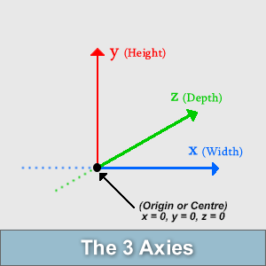
All 3D programs are based on a 3D co-ordinate system, more specifically, the Cartesian Co-ordinate system. These systems use X Y and Z co-ordinates to plot objects in 3D space. In a 3D Cartesian Co-ordinate System, there are 3 perpendicular lines or "axies" situated at right angles from each other, the X axies (horizontal), the Y Axies (vertical) and the Z axies (depth). Pretending you were standing on a plain, this Z line would run towards you and off into the distance.
These 3 axies intersect at a point know as the "Origin". Using a 3D Co-ordinate system, the Origin is located at position X = 0, Y = 0 and Z = 0, ie, the absolute centre point of your scene.
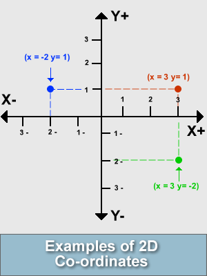
In order to start plotting points in our 3D system we need to understand how these values are related. If we travelled 2 units to the right hand side of the point of origin along the X axies our co-ordinates for this would read: X = 2 Y = 0 Z = 0. If we were to go back to the point of origin and travel 2 units to the left our co-ordinates would read: X = -2 Y = 0 Z = 0. Notice the negative sign infront of 2 for the value of X. Depending on which side of the point of origin we are situated on, the number will have either a positive or negative value. The following diagram demonstrates in a 2D co-ordinate system this principal.
![]() Note: All co-ordinate systems need a unit of measurement. Some 3D programs use familiar units of measurement like metres or inches or kilometres, where as others use custom made units, for example: "Bryce" units.
Note: All co-ordinate systems need a unit of measurement. Some 3D programs use familiar units of measurement like metres or inches or kilometres, where as others use custom made units, for example: "Bryce" units.
Co-ordinate Planes
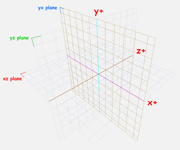
What is a co-ordinate plane? If our 3D program in question had a plane laying across the screen, the "ground" plane in this scene would be called the XZ Plane. The reason for this is that if we draw a line in a square shape around from the x+ to z+ then to x- and then to z- and then return back to x+ again, you would only be traveling in the 2 dimensions of X and Z. There are 3 of these planes in total. They are XZ, XY, and YZ or sometimes called only X Y and Z planes respectively. Strata CX is a 3D program that uses Co-ordinate plane grids in its user interface. These can be quite handy when you require a snap grid or a guide when lining up objects, when looking from different angles. A screenshot of the Strata 3D CX interfaces main window, with all 3 grids viewable at the same time is shown below. Obviously you would rarely need all 3 grids shown at once when using Strata, i have just enabled them all to show the example (the green, blue, red text has been added to make the 3 planes more obvious, as the picture is a bit faint).
(Click to enlarge)
This concludes the introduction to 3D co-ordinate systems tutorial
Chromesphere.com